History
Bandelier National Monument preserves more than 33,000 acres of the Pajarito Plateau in north-central New Mexico, protecting one of the densest concentrations of Ancestral Puebloan architecture in the American Southwest. The principal occupation of Frijoles Canyon spans roughly AD 1150 to 1600, with tree-ring dating placing the main pueblo's construction between 1383 and 1466. Sites within the monument document the Pueblo III and Pueblo IV eras, when ancestors of the present-day Cochiti, San Ildefonso, Santa Clara, and other Rio Grande Pueblo communities consolidated into the canyon's sheltered floor and along its south-facing cliff walls.
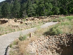
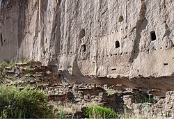
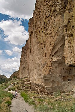
The builders employed two distinct construction traditions, both rooted in locally available volcanic material. Along the canyon walls they carved cavates — small, hand-hewn chambers — directly into the soft pinkish-white tuff deposited by the Valles Caldera eruptions more than a million years earlier. The same tuff, when broken into manageable blocks, was laid up as masonry to build talus houses against the cliff base and free-standing pueblos on the canyon floor. Walls were typically chinked with smaller stones and finished with adobe mud plaster, while floors, hearths, and roof systems were sealed with the same earthen mixture. This combination of carved rock and adobe-finished masonry represents a distinctly Puebloan vernacular adaptation to the geology of the Pajarito Plateau.
The centerpiece site is Tyuonyi, a single-entry circular pueblo of roughly 400 rooms that once rose one to three stories around a central plaza containing three kivas. Adjacent features include the Long House, a continuous run of multi-story talus dwellings stretching nearly 800 feet along the cliff, and Alcove House, a ceremonial space reached by ladders some 140 feet above the canyon floor. Petroglyphs and pictographs are preserved throughout the complex.
The monument was established by presidential proclamation on February 11, 1916, by Woodrow Wilson and named for Swiss-American anthropologist Adolph F. A. Bandelier, who documented the sites in the 1880s. It was added to the National Register of Historic Places in 1966. A Civilian Conservation Corps historic district at the visitor center, built of native stone and timber between 1933 and 1941, was later designated a National Historic Landmark. The site is administered by the National Park Service.
Notable features
- Ancestral Puebloan cliff dwellingsVernacular Adobe
- Tyuonyi circular puebloVernacular Adobe
- Cavates carved into volcanic tuffVernacular Adobe
- Masonry pueblo ruinsVernacular Adobe
- Frijoles Canyon settingVernacular Adobe
- Administered by National Park ServiceVernacular Adobe
Common questions
What is Bandelier National Monument?
Bandelier National Monument is a federally protected archaeological preserve in Los Alamos, New Mexico, covering more than 33,000 acres of the Pajarito Plateau. It safeguards one of the densest concentrations of Ancestral Puebloan architecture in the American Southwest, including cliff dwellings, masonry pueblos, and cavates carved into volcanic tuff.
When was Bandelier National Monument built?
The principal Ancestral Puebloan occupation of Frijoles Canyon spans roughly AD 1150 to 1600. Tree-ring dating places the main pueblo's construction between 1383 and 1466. The monument itself was established by presidential proclamation on February 11, 1916, by Woodrow Wilson.
Where is Bandelier National Monument located?
Bandelier National Monument is located at 15 Entrance Road, Los Alamos, New Mexico 87544. The protected area covers more than 33,000 acres of the Pajarito Plateau in north-central New Mexico, with its principal sites concentrated in Frijoles Canyon.
Can you visit Bandelier National Monument?
Yes, Bandelier National Monument is administered by the National Park Service and open to the public. Visitors can explore Tyuonyi pueblo, the Long House, Alcove House, and preserved petroglyphs and pictographs. A Civilian Conservation Corps historic district at the visitor center, built between 1933 and 1941, serves as the main visitor facility.
Why is Bandelier National Monument historically significant?
Bandelier preserves Pueblo III and Pueblo IV era sites built by ancestors of the present-day Cochiti, San Ildefonso, Santa Clara, and other Rio Grande Pueblo communities. It was added to the National Register of Historic Places in 1966, and its Civilian Conservation Corps visitor center was later designated a National Historic Landmark.
Who was Bandelier National Monument named after?
The monument is named for Swiss-American anthropologist Adolph F. A. Bandelier, who documented the archaeological sites of the Pajarito Plateau in the 1880s. His ethnographic and archaeological fieldwork in the region laid the groundwork for the area's recognition and protection.